Sujet
Map of Ypres, West Flanders, Belgium, First World War, (c1920). Creator: Unknown.
Légende
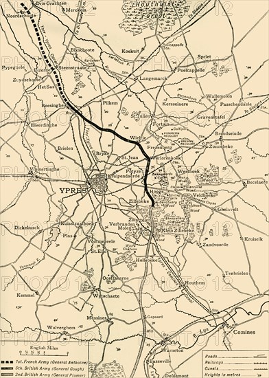
Map of Ypres, West Flanders, Belgium, First World War, (c1920). 'The Ypres Salient before the Battle of July 31, 1917: map showing the approximate positions of the Franco-British Line'. The Third Battle of Ypres, also known as the Battle of Passchendaele, took place on the Western Front from July to November 1917. It was fought between the British, Belgian and French armies against the Germans, and resulted in the deaths of hundreds of thousands of men. From "The Great World War: A History", Volume VII, edited by Frank A Mumby. [The Gresham Publishing Company Ltd, London, c1920]
Date
1917
Crédit
Photo12/Heritage Images/The Print Collector
Notre référence
HRM19F27_430
Model release
NA
Property release
NA
Licence
Droits gérés
Format disponible
62,6Mo (4,2Mo) / 33,5cm x 46,9cm / 3954 x 5536 (300dpi)