Sujet
'Plan of Westminster. (From Norden's Survey, taken in Queen Elizabeth's Reign, 1593)', (1881). Creator: Unknown.
Légende
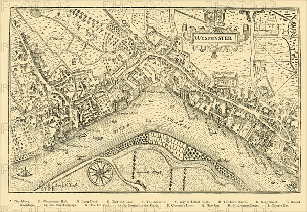
'Plan of Westminster. (From Norden's Survey, taken in Queen Elizabeth's Reign, 1593)', (1881). Bird's eye view, by cartographer John Norden (c1547-1625), of the village of Westminster on the River Thames, now part of greater London. Buildings and landmarks listed are: Westminster Abbyey, Westminster Hall, Long Ditch, Thieving Lane, The Amnerie, Way to Tothill Fields, The Lord Dacres, King Street, Round Woolstaple, The Park Lodgings, The Tilt Yard, St Martin's-in-the-Fields, Clement's Lane, New Inn, St Clement Danes, Temple Bar. Also visible is Convent (now Covent) Garden. From Old and New London: A Narrative of Its History, Its People, and Its Places. Westminster and the Western Suburbs, by Edward Walford, Vol. III. [Cassell, Petter, Galpin & Co., London, Paris & New York, 1881]
The Print Collector collection
Date
1881
Crédit
Photo12/Heritage Images/The Print Collector
Notre référence
HRM19D50_346
Model release
Non
Licence
Droits gérés
Format disponible
67,3Mo (4,9Mo) / 49,3cm x 34,2cm / 5817 x 4042 (300dpi)