Sujet
'Plan of Bankside, Early in the Seventeenth Century', (c1878). Creator: Unknown.
Légende
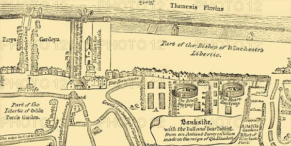
'Plan of Bankside, Early in the Seventeenth Century', (c1878). Map showing landmarks in the village of Southwark on the south bank of the River Thames ('Thamesis Fluvius'), in what is now greater London. Places shown include the Clink prison, and 'the Bull and Bear Baiting' rings in the liberty of the Bishop of Winchester. The Hope theatre was built in 1613 on the site of the old bear garden. From Old and New London: A Narrative of Its History, Its People, And Its Places. The Southern Suburbs, Volume VI, by Edward Walford. [Cassell, Petter, Galpin & Co., London, Paris & New York, c1878]
The Print Collector collection
Date
1878
Crédit
Photo12/Heritage Images/The Print Collector
Notre référence
HRM19D50_405
Model release
Non
Licence
Droits gérés
Format disponible
66,2Mo (3,4Mo) / 57,5cm x 28,9cm / 6787 x 3411 (300dpi)