Sujet
Siege of Sebastopol - map, 1854. Creator: Unknown.
Légende
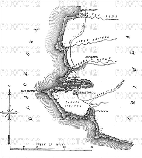
Siege of Sebastopol - map, 1854. Crimean War. The Black Sea, town and harbour of Sebastopol, Rivers Belbec, Katchka and Alma, Balaklava, roads to Eupatoria and Simferopol, Barren Steppes, Cape Constantine. 'The siege of[Russian-held] Sebastopol [by the Allied armies] bids fair to rank as the most remarkable operation in the annals of modern warfare. It is true we are no longer at a time when sieges were carried on with guns of small calibre, requiring a near approach to the walls to be effective against them. All the science of first parallel and second parallel is growing old, and armies, when they have advanced within 900 yards of stone walls, find that they are as close as they require; and, that with heavy 95 cwt. pieces, they can batter and breach to such purpose, that the work of a fortnight in the olden time is completed in twenty-four hours'. From "Illustrated London News", 1854.
Crédit
Photo12/Heritage Images/The Print Collector
Notre référence
HRM22B08_017
Model release
NA
Property release
NA
Licence
Droits gérés
Format disponible
10,4Mo (388,6Ko) / 15,3cm x 17,1cm / 1809 x 2014 (300dpi)