Sujet
Map of Central America shewing the Proposed Routes of Communication between the Atlantic & Pacific O Creator: John Dower.
Légende
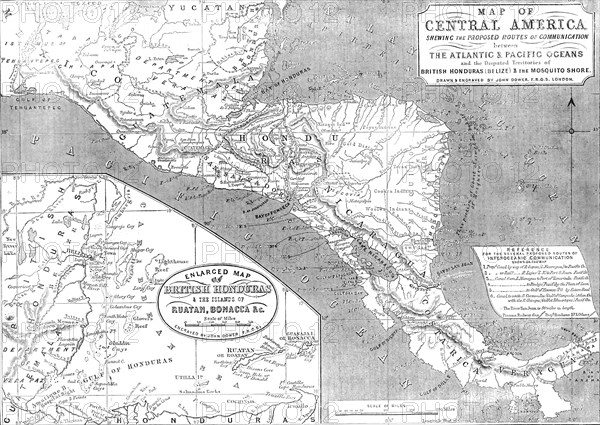
Map of Central America shewing the Proposed Routes of Communication between the Atlantic & Pacific Oceans, 1856. '...and the Disputed Territories of British Honduras (Belize) & the Mosquito Shore [with] Enlarged Map of British Honduras & the Islands of Ruatan, Bonacca &c...Reference for the several proposed routes of interoceanic communiciation: Proposed Canal by way of R. Sapoa...to Pacific Ocean...Railway [via] R. Lajas...to Port S. Juan...Canal from L. Managua to Port of Tamarinda...[Canal from L. Managua] to Realejo...by the Plain of Leon...[Canal from L. Managua] to Gulf of Fonseca...Canal to unite R. Coazacalco (Gulf of Campeche) Atlantic Ocean with the R. Chicapa (Gulf of Tehuantepec)...The River San Juan is 90 miles in length. [Key for] Panama Railway...proposed Honduras Railway and others'. European exploitation of the New World, note 'Gold District' and native tribes. From "Illustrated London News", 1856.
Crédit
Photo12/Heritage Images
Notre référence
HRM23A57_411
Model release
NA
Property release
NA
Licence
Droits gérés
Format disponible
63,3Mo (4,4Mo) / 47,3cm x 33,5cm / 5583 x 3961 (300dpi)