Sujet
Map of North-east China, showing the Gulf of Pechili, the Tien-Tsin (Peiho) River..., 1860. Creator: John Dower.
Légende
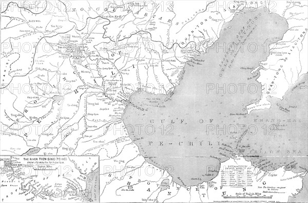
Map of North-east China, showing the Gulf of Pechili, the Tien-Tsin (Peiho) River, and the approaches to Pekin, 1860. 'By the latest intelligence from China we learn that the French and English expeditionary force is on the move northwards...The French force is reported to be about to rendezvous at Che-foo, on the coast of Shan-tung and in the Gulf of Pechili; and there will be also a station for British stores and troops on the opposite side of the Gulf. It is whispered that Sir Hope Grant may perhaps occupy Tien-Tsin before he attempts to take the Taku forts...the defences of [which] are very substantial...trenches or rifle-pits are to be used by the Chinese...the accompanying Map [shows] that portion of China where there is every likelihood of a death-struggle taking place. Chili, or Pechili, is the most northern province of China, having on its north Mongolia, on its east the Gulf of Pechili, and on the other sides the provinces Shan-tung, Shan-se, and Ho-nan...its population has been estimated at about thirty millions...it owes its importance to containing the capital, Pekin, and the great depots of rice and salt for the internal supply of the empire, and of the cattle sent into China from Mongolia'. From "Illustrated London News", 1860.
Crédit
Photo12/Heritage Images/The Print Collector
Notre référence
HRM23B08_031
Model release
NA
Property release
NA
Licence
Droits gérés
Format disponible
50,7Mo (2,2Mo) / 43,9cm x 29,0cm / 5184 x 3421 (300dpi)