Sujet
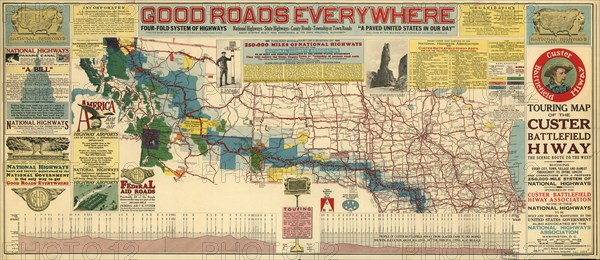
Touring map of the Custer Battlefield Hiway: the scenic route to the west, 1925. Creators: John C. Mulford, C. C. Faunce.
Légende
Touring map of the Custer Battlefield Hiway: the scenic route to the west, 1925. The Custer Battlefield Highway was created in 1925 as a scenic route between Iowa and Montana. The National Highways Association printed this large colored wall map, the Touring Map of the Custer Battlefield Hiway: The Scenic Route to the West," under a contract with the Custer Battlefield Highway Association. The association subsequently gave the map to its members. The highway began in Des Moines, Iowa, passed through Iowa, South Dakota, Wyoming, and Montana, and ended at the Canadian border in Glacier National Park. It was named in honor of George Armstrong Custer, the U.S. Army officer who was defeated and killed at the Battle of Little Bighorn by warriors of the Lakota Sioux, Northern Cheyenne, and Arapaho tribes. The map contains a topographic profile showing elevation changes along the route; a colored key highlighting national parks, national forests, and Indian reservations along the way; information about the route; and appeals for federal government support for building a national highway system. The scale in miles equates to 1:3,125,000."
Crédit
Photo12/Heritage Images/Heritage Art
Notre référence
HRM24A00_030
Model release
NA
Property release
NA
Licence
Droits gérés
Format disponible
173,4Mo (15,9Mo) / 100,0cm x 43,5cm / 11811 x 5132 (300dpi)