Sujet
Map of Glasgow, 1864. Creator: Unknown.
Légende
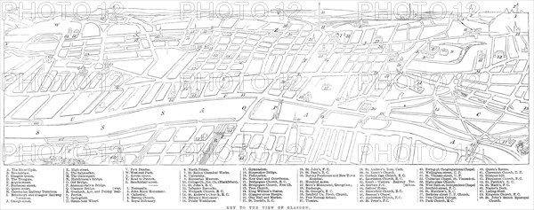
Map of Glasgow, 1864. 'This city is the largest in Scotland, and one of the greatest provincial towns in the United Kingdom. It stands in the county of Lanark, forty-two miles west-by-south of Edinburgh, on the banks of the Clyde. That noble river, after a course of 100 miles, discharges itself into the Firth, about twenty miles west of Glasgow, having the port and town of Greenock on the south bank of its estuary, where the river at length joins the sea...The view of Glasgow shown in our Engraving is taken from the south side. All the part which is properly called Glasgow lies on the north bank of the Clyde. On the south bank, in the foreground, are the ancient suburb of Gorbals with the modem suburbs of Hutchesontown on the east, or to the right hand, Laurieston, Tradeston, and Kingston, as far as Govan on the west, or to the left hand of the spectator. The city of Glasgow proper lies straight before him, in the middle of our Engraving, with the suburbs of Calton and Bridgeton on his right hand, and those of Anderston and Finnieston on his left, all forming one continuous town on the north bank of the river'. From "Illustrated London News", 1864.
Crédit
Photo12/Heritage Images/The Print Collector
Notre référence
HRM24A25_454
Model release
NA
Property release
NA
Licence
Droits gérés
Format disponible
35,7Mo (1,4Mo) / 47,6cm x 18,8cm / 5619 x 2223 (300dpi)