Sujet
Plan of the town and inland port of Ismaïlia, 1869. Creator: Unknown.
Légende
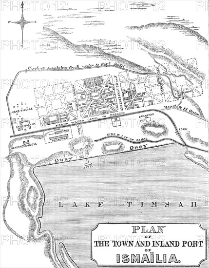
Plan of the town and inland port of Ismaïlia, 1869. Map of the town of Ismaïlia on Lake Timsah in Egypt, showing the freshwater canal and pipeline built at the same time as the Suez Canal. 'The rapid increase of vegetation since the fresh water was brought to Ismaïlia has been attended with a great improvement in the climate. At the present time Ismaïlia, during eight months of the year, is probably the healthiest spot in Northern Egypt. The heat of its summer is intense and almost intolerable; thermometrical observations taken during 1867 and 1868 show that the mean temperature of the four months, beginning with June and ending with September, was 94 deg. Fahrenheit, and that 120 deg. in the shade was not an uncommon record, while the minimum of night was 75 deg. The mean temperature of the succeeding four months was 74 deg.; and the winter, if so it can be called, proved that the lowest range of the thermometer was 45 deg. Until two years ago rain was unknown, but in the twelvemonth ending April, 1868, there were actually fourteen days on which rain fell, and no later than three weeks ago fell a tremendous shower of rain, a phenomenon which the oldest Arab had never previously witnessed'. From "Illustrated London News", 1869.
Crédit
Photo12/Heritage Images/The Print Collector
Notre référence
HRM24A34_409
Model release
NA
Property release
NA
Licence
Droits gérés
Format disponible
12,7Mo (706,8Ko) / 15,7cm x 20,2cm / 1858 x 2380 (300dpi)