Sujet
The Isthmus of Suez Maritime Canal: plan of the Harbour of Port Said, 1869. Creator: Unknown.
Légende
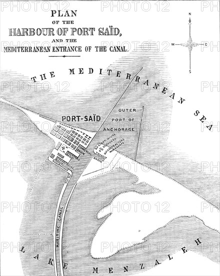
The Isthmus of Suez Maritime Canal: plan of the Harbour of Port Saïd and the Mediterranean entrance of the Canal, 1869. Map of '...the new artificial harbour [which] has been constructed by running out into the sea two breakwaters, or moles, which are formed of huge blocks of concrete...The western breakwater extends from the shore 2400 yards in a straight line towards the north...The eastern breakwater leaves the shore at the distance of 1530 yards of the commencement of the western breakwater, and extends nearly north for a distance of 2070 yards...the harbour is well protected from the strong and prevailing northwest winds. The portion of the harbour affording shelter to vessels is nearly 500 acres in extent; and, although the depth of water is not sufficient for the largest men-of-war, it is quite sufficient for ordinary merchantmen, if the present depth be maintained...The new town of Port Saïd now has a population of ten thousand persons. The basins, quays, and other accommodation at Port Saïd are very conveniently designed for the requirements connected with the traffic of the canal; and no doubt some of the repairing-shops now used for the temporary purposes of the works will permanently remain'. From "Illustrated London News", 1869.
Crédit
Photo12/Heritage Images/The Print Collector
Notre référence
HRM24A35_171
Model release
NA
Property release
NA
Licence
Droits gérés
Format disponible
13,3Mo (663,5Ko) / 16,4cm x 20,4cm / 1933 x 2412 (300dpi)