Sujet
The Nicobar Islands, in the Indian Ocean, 1870. Creator: Unknown.
Légende
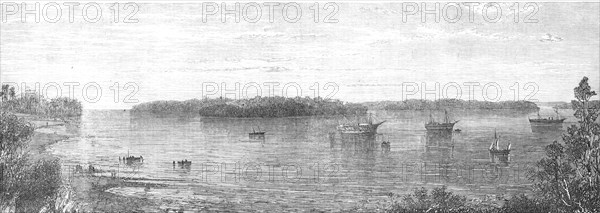
The Nicobar Islands, in the Indian Ocean, 1870. Sketch from a photograph by Captain J.M. Williams, Assistant Government engineer of Mysore, who accompanied the naval squadron's expedition. 'The recent occupation of the Nicobar Islands by the agents of the British Government, and their formal annexation to the Indian empire of Queen Victoria, as a remedy for the many outrages perpetrated by their savage inhabitants upon shipwrecked English crews, must be fresh in the public recollection...[The view shows] the north group of islands, lying around the spacious harbour of Nancowry, the western entrance to which is shown on the left hand and the eastern entrance on the right. The two hulks, Blenheim and Erin-go-bragh, employed on this station, are moored in the centre; on one side is the Kwang-Tung gun-boat, on the other is the schooner Lady Lawrence. In the island of Nancowry, which lies directly opposite, in the middle of this view, forming a natural break-water to the harbour, the projecting point to the right hand is named Port Mayo, in honour of the present Governor-General...The soil is of volcanic formation, and extremely fertile...[and] will yield sugar, tobacco, oranges, and various tropical produce'. From "Illustrated London News", 1870.
Crédit
Photo12/Heritage Images/The Print Collector
Notre référence
HRM24A49_371
Model release
NA
Property release
NA
Licence
Droits gérés
Format disponible
31,2Mo (1,7Mo) / 46,8cm x 16,7cm / 5530 x 1969 (300dpi)