Sujet
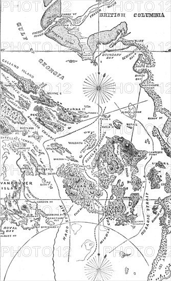
Map of the San Juan Archipelago, with the disputed channel and boundary, 1872. Creator: Unknown.
Légende
Map of the San Juan Archipelago, with the disputed channel and boundary, 1872. 'The publisher, Mr. Murray, of Commander Richard O. Mayne's " Four Years in British Columbia and Vancouver Island," which appeared in 1862, has favoured us with the loan of a "Sketch Map" of the Haro Archipelago, showing the Three Channels - namely, the line of division claimed by Great Britain, through Rosario Strait; the line claimed by the United States, through Haro Strait; and the intermediate line, through the Douglas Channel, which was suggested to compromise the dispute. The arbitration by the Emperor of Germany has now decided that the boundary shall be that which was claimed by the United States, running through Haro Strait; and the British empire is thereby deprived of the island of San Juan and other islands lying midway between the opposite shores of Vancouver Island and the Washington Territory of the American Republic...The strait that separates Vancouver Island from the American continent was discovered three hundred years ago by the Greek mariner, Apostolos Valerianos, who among the Spaniards was called Juan de Fuca; and the southern arm of this strait continues to bear his name'. From "Illustrated London News", 1872.
Crédit
Photo12/Heritage Images/The Print Collector
Notre référence
HRM25A06_134
Model release
NA
Property release
NA
Licence
Droits gérés
Format disponible
13,1Mo (717,8Ko) / 14,1cm x 23,2cm / 1669 x 2746 (300dpi)