Sujet
The East African Slave Trade: Mafamale Isle, mouth of the Angoxa, 1873. Creator: Unknown.
Légende
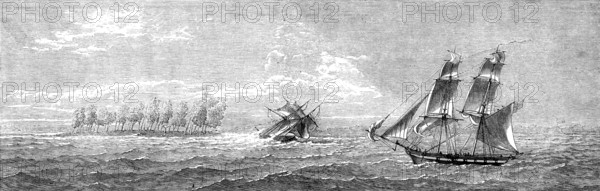
The East African Slave Trade: Mafamale Isle, mouth of the Angoxa, 1873. '...we have engraved for the present Number four views of Mozambique and the neighbouring territory, which were obligingly lent us by Sir William Parker,...having been drawn by him from slight sketches made on that coast a few years ago by his brother, the late Captain Hyde Parker...Sir William Parker writes: "Southward of Mozambique is the Angoxa river, which has a dangerous bar at its entrance, with a depth of from 2½, fathoms to 3 fathoms at high water, on which the sea breaks heavily with southerly winds. It is, however, navigated by dhows, though not safe, except with a leading wind. The river banks are law and sandy, with some casuarina trees. The inhabitants are a mixture of Arabs, blacks, and outcasts of all sorts. Their territory is nominally within the Portuguese dominions; but they are, in fact, perfectly independent, and under the rule of a Sultan. The entrance to the river is, to a certain extent, sheltered by an extensive coral reef surrounding Mafamale Island, on which in the Engraving a slaver is represented driven on shore by a man-of-war cruiser. The island above water has diminished in size since many of its trees were cut down for firewood".' From "Illustrated London News", 1873.
Crédit
Photo12/Heritage Images/The Print Collector
Notre référence
HRM25A13_112
Model release
NA
Property release
NA
Licence
Droits gérés
Format disponible
11,5Mo (1,2Mo) / 30,0cm x 9,6cm / 3546 x 1130 (300dpi)