Sujet
Maps of Africa, Upper Guinea, and the Gold Coast, showing the site of the Ashantee War, 1873. Creator: H. Crane.
Légende
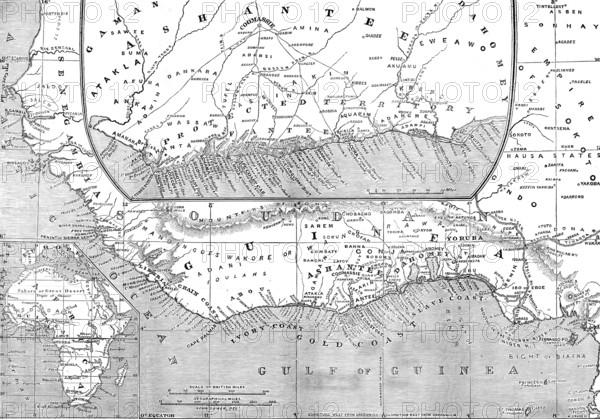
Maps of Africa, Upper Guinea, and the Gold Coast, showing the site of the Ashantee War, 1873. 'The name of Guinea is applied to the whole of that vast angle of the western coast...formed by the general shape of the entire continent...Upper Guinea begins at Sierra Leone and extends to the Gaboon River...It thus comprises the inner part of the great angle formed by the West African coast; this part is the Bight of Biafra, marked by the island of Fernando Po, opposite the Cameroon river and mountains of the mainland. The Upper Guinea Coast, between Sierra Leone and the Cameroons, stretching from west to east, but including the Bight of Benin, must be nearly two thousand miles in length. It is divided...into the Grain Coast, the Ivory Coast, the Gold Coast, and the Slave Coast, to which might be added the Palm-Oil Coast, these names indicating the chief commodities of merchandise for which those shores were resorted to by early navigators. The Portuguese, succeeded by the Dutch, were the first commercial colonists on the coast of Guinea; their place is now taken mainly by the British, established in several...forts and factories at the most convenient seaports - at Sierra Leone, at the mouth of the Gambia, at Cape Coast Castle, and at Lagos'. From "Illustrated London News", 1873.
Crédit
Photo12/Heritage Images/The Print Collector
Notre référence
HRM25A13_255
Model release
NA
Property release
NA
Licence
Droits gérés
Format disponible
56,0Mo (3,9Mo) / 44,8cm x 31,3cm / 5293 x 3701 (300dpi)