Légende
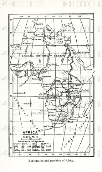
This map shows the exploration and partition of Africa during the late 1700s and the 1800s. The explorers whose routes are included are: Livingstone (1849-73); Barth (1850), Baker (1864); Brown (1796); Bruce (1768); Denham (1823-4); Stanley (1877-87); Callie (1827-8); Nachtigall (1872); Mango Park (1798); Cameron (1875); Clapperton (1823-4).
Crédit
Photo12/Universal Images Group/Ivy Close Images
Notre référence
UMG25A01_162
Licence
Droits gérés
Format disponible
53,5Mo (1,6Mo) / 28,2cm x 47,5cm / 3334 x 5610 (300dpi)